Threats

Sediment from a subdivision moving towards the Pauatahanui Stream


What threatens the Inlet?

The ecology of Pauatahanui Inlet is under threat from three primary sources — sedimentation, contamination and eutrophication (the increasing concentration of plant nutrients in a body of water). A fourth threat may yet come from local effects of climate change, which could include a rise in sea level, more rainfall and increasingly frequent storms.


A lot of the problems affecting the Inlet are due to the urbanisation of the southern and western end of the Inlet. GOPI is pleased to note that PCC, in its 30-year vision document, the Porirua Development Framework, does not envision further large scale urban development of the Pauatahanui Inlet basin, although some light industrial development may occur.


Sedimentation


The infilling of estuaries with sediment derived from erosion of catchment land is a natural process but the rate at which it occurs in the Inlet has been radically increased by human activity. Recent research shows that before humans arrived in the area, sediment accumulated in the Inlet at a rate of about 1 mm/year. The rate more than doubled during 1850-1950 as the forested land was converted to pasture.  During 1950-1985, a period when earthworks associated with urban development were ineffectively controlled, the rate trebled. At present the rate is about 4 mm/yr, though it is probable that a good part of this latest increase is due to changes in tidal flow caused by the building of the Mana marina bringing in more sediment from outside the Inlet.


As sediment builds up, the intertidal and salt marsh areas increase slowly and the deeper parts of the Inlet become shallower. Of more immediate concern for Inlet ecology is that the increased amount of sediment in the water reduces its clarity and the ability of eel grass and algae to photosynthesise and grow. Increased sediment also reduces the feeding efficiency of cockles and other filter-feeding animals and lays down more mud on the surface of the sand. From a human perspective there is a general shift towards an increase in less desirable species, such as mud snails, and a less visually attractive aspect at low tide – and one that may smell a bit too.


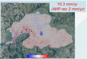
A 2009 bathymetric survey of Porirua harbour established the contours of the whole harbour, including the inlet (see image right). This precise information about the current depth of the Inlet will allow accurate monitoring of future changes caused by sedimentation.


What can be done about sedimentation?


·   Stop avoidable outflow of sediment from building earthworks. This is technologically feasible and requires local authorities to set appropriate conditions in resource consents and monitor compliance with them effectively.

·   Stop avoidable erosion in the catchment. This requires local authorities and landowners to cooperate in a revegetation programme that stabilises erosion-prone slopes and reduces the rate of erosion of stream banks. Greater Wellington Regional Council (GW) and Porirua City Council (PCC) are working together to achieve this through the Pauatahanui Vegetation Framework.

·   Investigate the feasibility of removing accumulated sediment. This may be a practical and desirable option but dredging must only be used where research shows that there will be no adverse effect on the ecology of the Inlet. PCC and GW are currently investigating whether a computerised hydrodynamic model of the harbour will enable the ecological effects of dredging to be predicted.


Contamination


The Inlet is subject to contamination from three sources: rubbish accumulating on the shore; water borne contaminants in storm water; chemicals derived from vehicles on roads around the Inlet. The first of these, rubbish piled up on the shore, is unsightly but easily dealt with. GOPI has an annual clean-up day and encourages local residents to adopt a patch of shore.

Contaminants in storm water

A great deal of storm water from urban hard surfaces (roofs, paths, roads, car parks, etc.) drains into the Inlet, either directly or via urban streams. There are 34 storm water outlets into the Inlet, 13 into Browns Bay alone.


Storm water carries soluble contaminants such as phosphates from detergents used for washing cars and zinc from galvanised iron roofs and other structures. Phosphates are plant nutrients and contribute to eutrophication. Zinc is poisonous to animals and in its soluble form is easily taken up by filter feeding animals such as cockles.


Storm water also carries sediment and particles of rubbish that contribute to sedimentation of the Inlet. Zinc and other heavy metals can chemically bind to these particles and thus build up the concentration of these poisons in the Inlet and pose a threat to mud and sand eating animals such as worms, and eventually to fish and birds higher in the food chain.


A further source of contamination from storm water can be seepage from nearby sewage systems. None of these sources of contamination need be a problem. They can all be filtered through artificial filters. Installing and maintaining such filters is, however, expensive and they have not been installed in the Inlet. Grass swales and water gardens act as natural filters, and are preferable to artificial systems, but these too are missing from the Inlet.

Vehicle-related contamination

The Inlet is ringed by busy roads. Rain on road surfaces washes the accumulated dust from vehicle brake pads and tyre wear into the Inlet. These substances contain heavy metals such as zinc, copper and cadmium, sooty residues from partially burnt petrol and diesel, and unburnt hydrocarbons from fuel and oil spillages.


These are all serious pollutants. They adversely affect the biology of many estuarine plants and animals. Particularly vulnerable are predatory species, including humans, that eat large numbers of polluted prey.


As with storm water, all these pollutants can be filtered off harmlessly through grassed swales. A swale between the road and the inlet can also act as a pedestrian pathway.


Because of this threat of pollution from traffic-dense roads GOPI supports the building of Transmission Gully, which should take away most of the traffic between Kapiti and the Hutt Valley that currently uses SH 1 and Grays Road (see Roading Policy).


Eutrophication


Eutrophication, the increasing concentration of plant nutrients in a body of water, would obviously increase algae and eel grass growth. If the eutrophication process is continuous, in the long term the quicker growing algae will end up smothering the eel grass and depriving the surface layers of the sand banks of oxygen. This oxygen deprivation would lead to the death of much of the bottom dwelling fauna. Moreover, the algae that respond most quickly, e.g. sea lettuce, are not desirable food for herbivorous birds and animals. The Inlet and its intertidal banks would become covered with a slimy and evil smelling ankle deep mess of live and decaying algae.


The nutrients, mostly high in nitrogen or phosphorus, derive mainly from agricultural fertilisers in the catchment and effluent from stock, with some input from poorly designed or maintained septic tanks. Luckily, the stock component in the Inlet catchment is minor and can be minimised by keeping stock away from stream edges. Leaching of fertiliser from soil is more difficult to control but intelligent revegetation practices, such as those advocated by the Pauatahanui Vegetation Framework can be very helpful.


Climate change


The effects of climate change on the Inlet simply don’t bear thinking about. The predicted increase in annual rainfall and in frequency of severe rain storms could increase erosion in the catchment, and thus sedimentation of the Inlet. A rise in water temperature would accelerate the rate of eutrophication. Even a small rise in sea level would impact heavily on the Wildlife Reserve and its breeding birds and would cause transport difficulties along SH 1 and Grays Road.


Last Updated: 22/11/2010 2:29pm